
The Mysterious Meandering Mississippi: Extreme Weather Risks the Old River Control Structure and the U.S. Economy

Figure 1: Changes in the path of the Mississippi River water flow over a long-term time scale.
Introduction
The Mississippi River, at more than 3,800 miles long, flowing through 10 states and providing drinking water to 30 million Americans, is worth hundreds of billions of dollars to the U.S. economy annually. But the Mississippi River, like all rivers, meanders back and forth along its path: In this case, the Mississippi Delta from Texas to Louisiana and back again.
The U.S. Government built the Old River Control Structure in 1963 to manage the meandering Mississippi River and channel the river permanently through Baton Rouge and New Orleans.
While the Old River Control Structure is a technological marvel, in its ability to channel the Mississippi River, an increase in extreme weather forecasting of 60% greater water volume through the Mississippi River leaves the economies of Texas and Louisiana extremely vulnerable to climate change and risks from extreme weather.
With extreme weather increasing, it now may be possible that an unprecedented and catastrophic failure of the Old River Control Structure would cause billions of dollars in damages to the Louisiana and Texas economies, and investors are not paying attention due the meandering Mississippi River and its potential consequences (Figure 1).
The Influence of Rivers: Harnessing their Power
It would not be exaggerative to say that rivers have left a significant imprint on the growth of humanity. Even the origins of human civilization can be traced back to early settlements along the ancient Tigris and Euphrates River systems. Trade, agricultural irrigation, and major transportation routes were among the key factors in this growth: a trend that has continually emerged over centuries. Major rivers systems and their respective tributaries have always been hubs of human life, where trade, social structures, and culture have grown and thrived along their banks.
However, as technology has exponentially improved, so too has our desire to harness the entirety of, and exert control over, rivers. Man-made river control systems, while evolving over the past decades, provide a quintessential example. The Old River Control Structure (ORCS) is one of the most important structures in the US, providing food, fresh water, and protection from the Mississippi to Americans.
While ORCS was considered a key success at the time it was built, it is ridged and controlling in nature—a stark contrast to the Mississippi itself. Changes in the Mississippi are leading to increased and intense risks, and a new management plan is needed to prevent what could be hundreds of billions of dollars in cost. Over time, the hydrology of the water, also known as the physical properties of the water and its interactions with its environment, have shifted the river’s channel through water flow erosion and deposition from the Mississippi’s flow.
Furthermore, climate change, and the increased risks it brings to the table are compounding risks in an already difficult situation, further highlight a need for a change in management of ORCS: one that may need a shift towards letting nature help fix itself.
Atchafalaya Basin: The Ecological history of the Atchafalaya Basin
The Atchafalaya Basin is in south central Louisiana and is a were the Mississippi river and the Gulf of Mexico converge. It includes a combination of varies ecosystems categorized as wetlands, rivers, and a growing delta system.
The significance of the Atchafalaya Basin, or the land as a biodiversity hub, cannot be overstated. The U.S. EPA categorizes the Atchafalaya Basin as the largest wetland area in the United States, and the third largest in the world, after the Amazon and Congo Basins. Besides the previously stated historical impact on human economic and fishery history, the Atchafalaya Basin encompasses additional, vital roles to ecosystems as a wetland.
The Old River Control Structure: The Mississippi and the Old River Control Structure
The Mississippi river has experienced change over the past centuries. In Louisiana, the river has changed course, creating new channels while abandoning others (Figure 2). From Old River itself to the Gulf of Mexico, the natural gradient of the Mississippi River passes down the Atchafalaya River, which is half the distance and twice as steep as the present route. Moving unconstrained, the Mississippi River would have followed this shorter path.
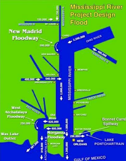
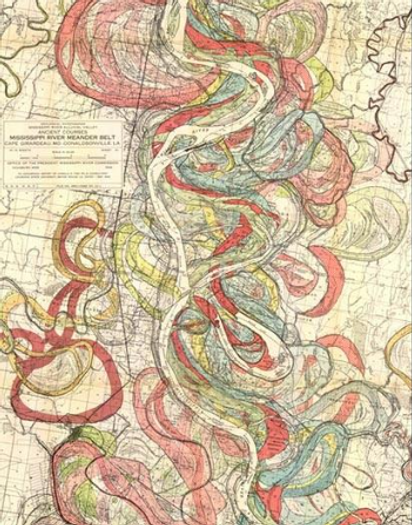
Figure 2: Two views of the Mississippi River. Left: the meander paths of the Mississippi over time, as published in "Geological Investigation of the Alluvial Valley of the Lower Mississippi River" (Harold N. Fisk, 1944, available online). Right: The Army Corps of Engineers' view of Mississippi River, with peak flow rates in cubic feet per second for a maximum 1-in-500-year "Project Flood”. The Corps has straightened the river’s path by cutting off meander bends, and has built multiple flood control structures capable of diverting a portion of the river's flow.
However, as US business became increasingly dependent on the Mississippi in the 19th and 20th centuries, its flow became more meticulously managed. The Atchafalaya River, initially a small distributary, was cut off from the Mississippi by Captain Henry Shreve’s 1831 shortcut through Turnbull's Bend (the previous intersection). Despite Shreve’s cut, the Atchafalaya began to take in a greater share of the Mississippi’s flow in the 1900s, posing a risk to the river's primary channel. Indeed, in the 1950s, 30% of the Mississippi River's waterflow was naturally diverted to the Atchafalaya River. The U.S. Government forecasted that the Mississippi River would change course to flow down the Atchafalaya River instead of through Baton Rouge and New Orleans by the 1990s.
In response, the U.S. Army Corps of Engineers finalized the Old River Control Structure in 1963 to avert this shift (Figure 3). Today, this system, which includes an additional damn constructed in 1986, manages the river’s flow with a division of 70% to the Mississippi and 30% to the Atchafalaya. River avulsion and flooding strain support a growing push to reevaluate the feasibility of controlling the Mississippi indefinitely.

Figure 3: Components of the ORCS system. The four primary components are The Old River Low Sill Structure, Overbank Structure, Old River Lock and the Auxiliary Structure, with the first being constructed in 1962 and 1963, with the latter added to the complex in 1986 to supplement flood damage. With these components in place, the Corps effectively managed a 70/30 split to the Mississippi and Atchafalaya, as mandated by Congress. The Sidney A. Murray Jr. Hydroelectric Station, constructed in 1990, is the final component of ORCS. The station uses the abundant energy resources of the rivers’ intersection to generate more power than any other plant of its kind.
Engineering a shift in the Mississippi’s Flow
The Old River Control Structure (ORCS) – a series of four dams located on the river between Baton Rouge and Lafayette – was constructed by the US Army Corps of Engineers in 1963 to help manage the consequences of these shifts. The structures prevent the diversion of the Mississippi to the Atchafalaya and shift it through Baton Rouge and New Orleans (Figure 4, Figure 5, Figure 6, Figure 7, and Figure 8).
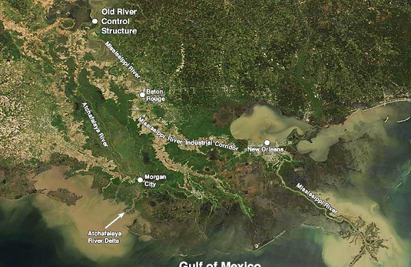
Figure 4: Louisiana as seen by the MODIS instrument on March 21, 2019, showing the location of the Mississippi and Atchafalaya rivers, plus the Old River Control Structure, which diverts 30% of the flow of the Mississippi into the Atchafalaya. Floods of the two rivers were creating large sediment plumes in the Gulf of Mexico. Image credit NASA.
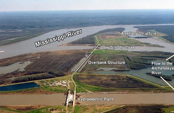
Figure 5: Aerial view of the four structures of the Mississippi River Old River Control Structure, looking downstream to the south. Water flows from the Mississippi River through the four structures, to the Atchafalaya River (right). Image credit: U.S. Army of Engineers. Special thanks to Dr. Jeff Masters.
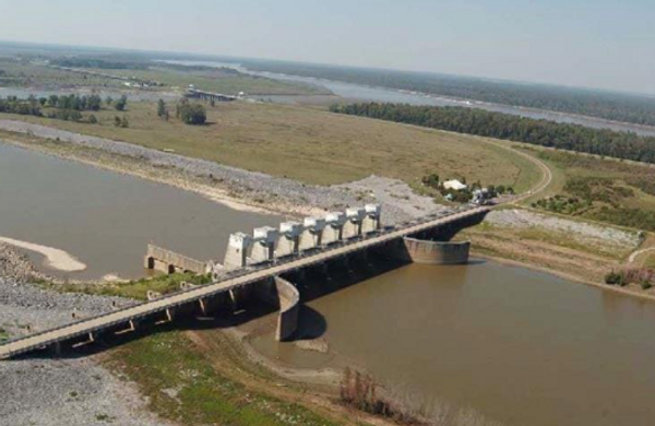
Figure 6: The Auxiliary Structure, the keystone of the $1 billion Old River Control Structure, which keeps the Mississippi River from changing channels. The main channel of the Mississippi River can be seen in the distance. Image credit: U.S. Army Corps of Engineers. Special thanks to Dr. Jeff Masters.

Figure 7: The Old River Control Structure’s Low Sill Structure in April 1973. Scouring from a 1-in-40-year flood caused the 67-foot-long southern wing wall on the intake channel leading to the Mississippi River to collapse on April 14, and a large eddy (red circle) formed where the wall used to be. The eddy scoured out a 50-foot-deep football field-sized hole that undermined seven of the structure’s 11 gates and nearly caused its failure. A ramp leading to the eddy was built, and an emergency stone replacement dike was built. Image credit: USACE. Special thanks to Dr. Jeff Masters.

Figure 8: Aerial photograph of the initial opening of the Morganza Floodway during the great flood of May 14, 2011. Water is flowing from the Mississippi River (upper left) into the Atchafalaya Floodway, from left to right. Credit: USACE. Special thanks to Dr. Jeff Masters.
While ORCS was seen as a success at the time, its channeling of the Mississippi River has left the economies of Texas and Louisiana vulnerable to climate change and extreme weather events. Specifically, extreme weather events forecast 60% greater water volume in Mississippi River in the mid-term, generating unprecedented stress on the structure. Long term buildup of sediment, which plugs the river channel, further exacerbates such events and increases flood risk.
As sedimentation and extreme weather grow in frequency and severity, the once remote threat of catastrophic failure of the Old River Control Structure is now a material risk with the potential to inflict hundreds of billions of dollars in damage on Louisiana and Texas (Figure 9).
Structural failure, resulting in the sudden diversion of the Mississippi into the Atchafalaya River, would make navigation down both the old and new river channel virtually impossible for months. Ports in New Orleans and Baton Rouge, which handle over 60% of U.S. grain exports as well as critical petrochemical and energy shipments, would be critically impaired (If the Old River Control Structure Fails: A Catastrophe With Global Impact | Weather Underground). Disruption could cost the U.S. economy up to $295 million per day, with long-term losses reaching tens of billions of dollars due to halted trade and supply chain breakdowns (Weather Underground).
Consequent flooding of the Atchafalaya Basin would also threaten major towns like Morgan City, destroying vital oil and gas infrastructure and disrupting energy supplies, leading to fuel shortages and price spikes across the South. Similarly, a failure in the structure could devastate agriculture, fisheries, and ecosystems, particularly when compounded with other increasing climate risks (If the Old River Control Structure Fails: A Catastrophe With Global Impact | Weather Underground).
Altering the structure of the Mississippi control systems in accordance with the river’s natural flow, as well as flexible and adaptive management of surrounding biodiversity, is continuing to show a positive sign towards mitigating climate risks, a notion that is showing to be more and more popular among the science and business worlds alike (Figure 9).
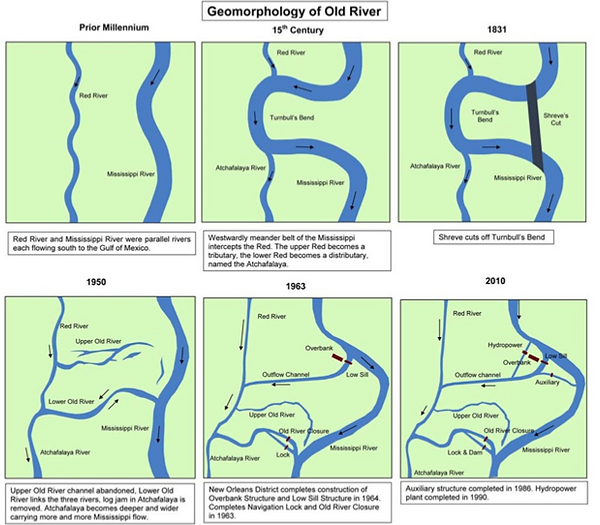
Figure 9: Map of ORCS structure changes over the last few decades. Includes specific structures and flow of Mississippi river.
While managing an organic shift in the Mississippi River’s path confronts years of strictengineering oversight, it is supported in research. In his 1983 study, Possible Capture of the Mississippi by the Atchafalaya River, engineer John D. Higby Jr. posited that the complete capture of the Mississippi by the Atchafalaya was unavoidable, raising doubts about long term sustainability of ORCS.
He suggested forming a congressional commission comprised of leading limnologists to rethink long-term policy, even proposing that the U.S. might allow the river to gradually alter its course at the Old River Control Structure (ORCS) over the next 50 to 100 years. Additional researchers, such as Corps geologist Charles R. Kolb and ecologist Richard E. Sparks, have supported this approach of collaborating with nature, highlighting that sheer opposition to environmental forces can be both impractical and perilous over time.
Climate change risks only add a compounding effect to the changes that Mississippi is currently experiencing. Risks that are already being felt by people and nature alike.
The Mississippi and U.S. Economic Risk
An abrupt and catastrophic collapse of the Old River Control Structure would have far-reaching and immediate effects. Shipping grains out of the United States by barge down the Mississippi accounts for 60% of all grain exports. Located to the south of Baton Rouge are four of the fifteen largest ports in the country. The nation might lose as much as $295 million daily if the ORCS were to collapse, which would interrupt the entire supply chain.
ORCS collapse and the consequent shift to the Atchafalaya would wreak havoc on major cities like Baton Rouge and New Orleans. Their water supply comes from the Mississippi, and the river's consistent flow is vital to the regional economy. Because of the intrusion of Gulf saltwater into water systems, the depletion of freshwater supplies, and the relocation or collapse of industries, the Atchafalaya River would be an undesirable consequence of a river jump.
As the Mississippi River follows the narrower and steeper course of the Atchafalaya, its hydrological characteristics would cause it to flow faster, continuing a positive feedback loop with devastating consequences.
The erosion at the delta would worsen, coastal defenses would be overwhelmed, and land loss would accelerate through said increasing erosion, furthering the cycle.
Flooding and infrastructure failure downstream are likely outcomes of the Atchafalaya's inadequate capacity to manage the full force of the Mississippi, even after being widened for decades.
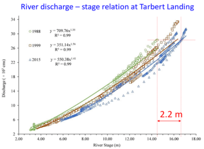
Figure 10: Changes in discharge rate at the Mississippi River Tarbert Landing gauging station near the ORCS system. Long-term response of flow, due to increased sedimentation from river engineering. Source.
A paper by Munoz et al. (2018), also found a similar conclusion to the human-made constructions along the Mississippi river. They constructed a 500-year history of floods in the Mississippi by studying sediment cores and found that the magnitude of what they defined as 100-year floods (A flood with a discharge rate containing a one percent change of being exceeded in any year) has increased dramatically Climatic control of Mississippi River flood hazard amplified by river engineering | Nature (Figure 10).
Among other findings, they estimated that roughly 75% of the increases are attributed to river engineering feats such as ORCS. The interactions of human changes to the Mississippi River system with climate variability has “increased the risk of “current flood hazards to levels that are unprecedented within the past five centuries”. This alarming determination, supported by data and opposing previous belief, reveals once again the difficulty in managing rivers that can change in quick succession. While systems like ORCS have saved billions of dollars in prevention in the past, they are also leading to increased floods that were not predicted, as well as other indirect costs to the environment.
Flooding accelerates coastal land loss as well, due to the less river sediment being deposited on the coast, while the tides take it away. The change in this balance has led to undesired consequences, including creating oxygen-depleted zones that kill marine life in the river deltas. The destruction of habitat, i.e., the degradation of natural ecosystems, as well as the loss in biodiversity created by increased flooding, is also extremely costly to locals, a feature that climate change is also accelerating. The relationship between human systems like ORCS and its surrounding natural ecosystems also created indirect consequences financially, something that will be emphasized further on.
Threatening Developments: Environmental and Structural Stress
Despite its longevity and strength, the ORCS structures are prone to breakage soon. Sediment accumulation over time has slowed the flow of the Mississippi as it nears the ORCS. When there is a big flood, the "plugging effect"—where sediment piles up along the river to slow down water flow—causes a rise in water level, making overtopping or structural failure more likely. For the same flow rates since 1988, sedimentation has caused flood heights downstream from the ORCS to rise by over seven feet. Worse still, climate change is accelerating the problem. Rising precipitation and runoff could cause Mississippi River flow rates to increase by 60% by the century's end, according to a study done in 2014.

Figure 11: Maps of estimated percent change of precipitation (a), soil moisture (b), evapotranspiration (c), and runoff (d), between 2005-2056, and the coming decades (2050-2100).
Scientifically, the ORCS plays a crucial role in sediment transport and water quality, which are essential for the health of both aquatic ecosystems, and human systems as well. A collapse would lead to increased changes in sedimentation in some areas and erosion in others, altering habitats and affecting species like the pallid sturgeon that require specific conditions for spawning. Moreover, changes in nutrient distribution could impact plant growth, affecting food availability for herbivores and, consequently, the entire food chain. Such ecological disturbances would not only threaten biodiversity but also impact industries like fisheries and agriculture that depend on these ecosystems.
However, the damming and channelization of the Lower Mississippi, which the ORCS plays a central role in, are a major cause of the degradation of coastal wetlands (National Water Summary Wetland Resources: Louisiana). Wetlands, as currently defined by the Ramsar definition, include any land area that is saturated or flooded with water, either seasonally, or permanently. The decreased suspended-sediment load, as stated in the earlier risks section, among other fundamental shifts in human activity along the lower Mississippi such as dredging, drainage for development, and drainage for crop production, have all contributed to the degradation of wetlands in the area.
This is significant because wetlands, in general, are becoming more and more critical to human activity, being estimated to provide around $47.7 trillion a year in ecosystem services globally (Financial incentives for large-scale wetland restoration: Beyond markets to common asset trusts: One Earth). Maintaining biodiversity, regulating and removing nutrients from excessive agricultural inputs, carbon sinks for reducing CO2 naturally, and even overall maintaining a healthy water quality are all features of wetlands that make them uniquely advantageous.
Certainly, from a human health and resource perspective, the impact that wetlands can provide are fundamentally important to our planet responding to human made stressors. Fisheries continue to be a key part of the Louisiana economy. The Fishery industries reportedly maintain a high level of economic impact-- nearly $2.4 Billion annually, and nearly 1 in 70 jobs in the state are related to the Fishery Industries (source is not the most credible Industry | Louisiana Seafood). Shrimp, oysters, crabs, and crawfish fisheries are all massive sources of economic growth in the state. From a biological lens, the flooding and threatening breakage of the ORCS system, and therefore subsequent increased risk of wetland degradation in the area, highlight the compounding nature of present risks.

Figure 12: Example of what a hypothetical portfolio of wetlands might look like. Source.
In a similar vein to the ORCS River Control Structure, the ability to control how the Mississippi flows has led to a short-term boom, but as these wetlands are reduced, management philosophies and plans need to continuously updated to account for changes (Figure 12).
While these features have representative indirect impacts on human life, direct impacts have been historically significant for Southern Louisiana, and these impacts are only heightened by climate change risks.
The relationship between human activity and wetland degradation is systematically intertwined, in the same way that decreases in biodiversity are linked with climate change: the occurrence of positive feedback loops are almost certain to occur. The level at which these systems are interconnected, as well as the financial impacts that stem from them, mean that one cannot consider changing the actions of one management system. Rather, all avenues must be considered for the full effects to take shape.
Compounding Effects: Financial Impact of Storms on Southern Louisiana
In terms of both risk and cost, one of the largest and most intimidating effects of climate change is the increase in frequency and severity of storms, labeled on the Saffir-Simpson Hurricane Wind Scale as a category 3-5 storm. Large and intense storms such as hurricanes can put an exorbitant amount of stress on the structural integrity of man-made buildings, and the ORCS system is no different, adding to an already intense risk. The location of Southern Louisiana, and systems and structures like ORCS as a byproduct, have historically been at the forefront of tropical storms. Storms like Hurricane Katriana and Hurricane Harvey are two of the most intense and costly storms, both by scientific definition and through a humanistic perspective.
Category 3-5 hurricanes are defined as “major” where on the smaller end of the scale sustained winds can get up to 129 mph (177km/h) and as far as over 157mph (252km/h) on the higher sides. The Saffir-Simpson Scale (utilized by NOAA) also defines these hurricanes by simply saying: “catastrophic damage will occur”.
These tropical storms are fueled by the warm ocean waters in the Gulf of Mexico and will continue to increase because of warming ocean waters. The frequency of moisture accumulation and precipitation, as seen earlier, provides even more fuel for the metaphorical fire. Hurricanes, by definition, are positive feedback loops, which coincidentally makes then a fundamental indicator of why the combination of risks are compounding. From a humanistic lens, these storms are extremely detrimental towards human health and safety, as well as material and collateral damage.
Hurricane Katrina alone, a storm that the people of Louisiana are very familiar with, has been estimated to cause $150 billion dollars, which was over 1% of the GDP for the entire united states in 2005. While damages from hurricanes have a nonlinear relationship with intensity (Normalized US hurricane damage estimates using area of total destruction, 1900−2018 | PNAS), the sobering reality is that Katrina was only considered a Category-3 storm when it hit land.
The ORCS River system, besides flood risk, is put in a precarious position by increasing storms, both in severity and in frequency. Internal flood risk from the Mississippi—the very river ORCS was built to manage—and external risk from hurricanes are a recipe for disaster.
Human health and safety, as well as serious financial risk, means that it is even more imperative that a practical, proactive, and preventative management strategy that includes reevaluating the status of the ORCS system is crucial.
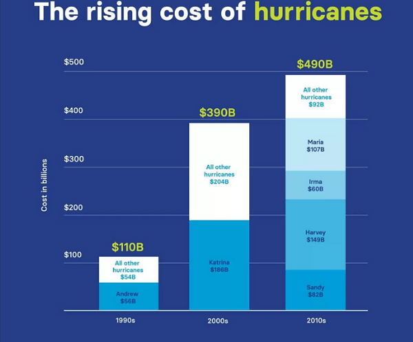
Figure 13: Cost of Hurricanes from 1990s to 2010s (in billions of dollars), estimated by NOAA.
Wetlands as Regulators: The Value of River Control Systems and the Wetlands Around Them
As discussed previously, hurricanes are extremely costly. But when contextualizing the full extent of their cost, we must also understand how they impact the environment, and how biodiversity is a key part of storm protection and mitigation (Figure 13).
Wetlands provide an incredibly valuable role in maintaining ecosystem homeostasis, as in how the ecosystem can deal with stress and maintain regular health. The balance of nutrient regulation, the removal of excessive pollutants, as well as being a home for a variety of unique biota, wetlands are some of the most hearty and capable ecosystems our planet has to offer. Perhaps one of the most relevant capabilities, however, is that they are natural barriers and help provide protection from flooding, storms, and other potential disaster events.
A study in 2008 tried to catalog the “value of wetlands”, particularly regarding hurricane protection. Using mapping of annual probability of hurricane hits, and modeling relative damages, they found that wetlands in the US were estimated to provide over $23.2 billion in storm protection, self-maintaining as ‘horizontal levees’ for storm protection, as opposed to man-made, vertical levees. The Value of Coastal Wetlands for Hurricane Protection on JSTOR.
While this was one specific case in methodology and, model, and analysis, this is a commonly understood and accepted idea in the science world, that nature may be better at self-regulation; perhaps better than we ever will be. The value of damages had from hurricane Katrina alone, according to this studies model is estimated to be upwards of $1.1 Billion dollars (using the area of wetlands lost before and during the storm), further highlighting the need for a more inclusive prevention strategy.
Assessing the financial value of wetlands can be difficult, but understanding their critical roles, and how we can harness them in relation to an improved ORCS system is incredibly valuable. Dual management, particularly in restructuring the ORCS system around its biodiverse wetland counterpart, rather despite it, could be crucial towards reducing the massive risks around it currently.
Be Natural: Let the Mississippi River Naturally Change
In 1983 engineer John D. Higby Jr. wrote a study called Possible Capture of the Mississippi by the Atchafalaya River. He stated that capture of the Mississippi River by the Atchafalaya was inevitable, and he questioned the Corps' assertion that the present status quo could be maintained into the “foreseeable future” (source).
Higby recommended the creation of a congressional commission "made up of the world's foremost professionals in river engineering, geology, and water resources policy and planning" to make recommendations on the future of Mississippi River policy.
His most eye-opening recommendation was to consider allowing the river to change its course slowly and under controlled conditions at Old River, and eventually abandon the Old River Control Structure, perhaps over a period of 50 to 100 years.
Other experts, such as Corps of Engineers geologist Charles R. Kolb and retired University of Illinois ecologist Richard E. Sparks, have echoed similar ideas. Said Sparks in his essay, Rethinking, Then Rebuilding New Orleans, "the most sensible strategy is to work with the forces of nature rather than trying to overpower them."
The Price of Redemption
An abrupt and catastrophic collapse of the Old River Control Structure would have far-reaching and immediate effects. Shipping grains out of the United States by barge down the Mississippi accounts for 60% of all exports. Located to the south of Baton Rouge are four of the fifteen largest ports in the country. The nation might lose as much as $295 million daily if the ORCS were to collapse, which would interrupt the entire supply chain (Figure 14).
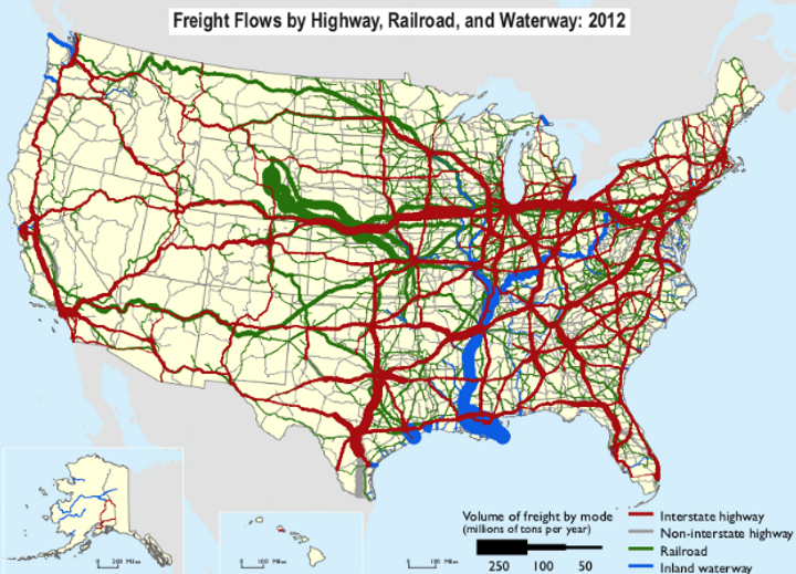
Figure 14: Freight Flows by Waterway, Rail, and Highway, 2012. Source: Weather Underground. Special thanks to Dr. Jeff Masters.
It would wreak havoc on major cities like Baton Rouge and New Orleans. Their water supply comes from the Mississippi, and the river's consistent flow is vital to the regional economy. Because of the intrusion of Gulf saltwater into water systems, the depletion of freshwater supplies, and the relocation or collapse of industries, the Atchafalaya River would be an undesirable consequence of a river jump.
As the Mississippi River follows the narrower and steeper course of the Atchafalaya, its hydrological characteristics would cause it to flow faster. The erosion at the delta would worsen, coastal defenses would be compromised, and land loss would accelerate. Flooding and infrastructure failure downstream are likely outcomes of the Atchafalaya's inadequate capacity to manage the full force of the Mississippi, even after being widened over decades.
Shifting Strategy: Manage Now Towards the Natural Flow of the Mississippi
Permitting the Mississippi River to organically alter its path in a managed way confronts years of rigid human control. In his 1983 study, Possible Capture of the Mississippi by the Atchafalaya River, engineer John D. Higby Jr. cautioned that the natural capture of the Mississippi by the Atchafalaya is inevitable, raising concerns about the timing of such an event. He voiced doubts regarding the U.S. Army Corps of Engineers' assurance in sustaining the existing flow regime over the long term and suggested the establishment of a congressional commission made up of leading experts in river systems and policy to reevaluate management strategies for the future. In a bold proposal, Higby recommended that rather than strictly opposing natural processes, policymakers might explore the option of gradually permitting the Mississippi to shift its course toward the Atchafalaya through managed approaches—possibly leading to the eventual decommissioning of the Old River Control Structure (ORCS) over the next 50 to 100 years.
This proposal does not stand alone. Experts such as Corps geologist Charles R. Kolb and ecologist Richard E. Sparks advocate for methods that honor and collaborate with natural systems, rather than trying to control them. In his essay Rethinking, Then Rebuilding New Orleans, Sparks emphasizes the importance of embracing nature's force instead of fighting against it—a perspective that is increasingly relevant as climate change increases flood risks and places additional pressures. Permitting the Mississippi to gradually shift its path, with careful oversight, may lower the chances of disastrous collapse while allowing the communities that rely on the river—human, plant, and animal—to continue to thrive.
The nature of the relationship between ORCS and the surrounding wetlands of the Atchafalaya Basin also calls for a dual action plan: Flexible-planning and management in conjunction with better investment into restoration of wetlands. The importance of maintain this relationship, while also cultivating a healthier one in response to compounding climate risks will both indirectly and directly aid human and nature alike—A philosophy that is continually making itself known.
Smart Management: Compounding Benefits Negate Compounding Risks
An important part of controlling the flow of water between the Mississippi and Atchafalaya Rivers is the Old River Control Structure (ORCS), but increasing environmental stressors highlights a need for a more proactive management system. The day will come when structure gives way from the increased sediment deposition, more intense floods, and predicted rise in Mississippi River flow rates caused by climate change.
Major policy frameworks, including the $50 billion 2017 Coastal Master Plan in Louisiana, fail to address the threat of ORCS failure and its potentially disastrous consequence. Structural failure and drainage into the Atchafalaya would destroy Baton Rouge and New Orleans, cutting off their access to water, shipping lanes, and economic opportunities. Preparing for this kind of event is not alarmist; rather, it is a vital step supported by historical experience and scientific consensus.
It may not be a matter of "if," but "when" the Mississippi River rebels, given that sedimentation heightens flood risks, and climate change also quickens the hydrological stress. The reality is that we must be prepared for the inevitability that the ORCS will fail, despite it having been key in preserving infrastructure, population centers, and commerce for decades. Compounding effects of climate change, in conjunction with risks towards wetland degradation, highlights a critical need for realistic, proactive, and flexible planning, rather than denial-based, rigid, long-term thinking. The most sustainable way forward is managed adaptation, which is guided by science, policy foresight, and respect for natural systems.
By doing so, the improved health of the ORCS structure would be better flexibility towards the Mississippi changes, therefore decreasing risk. This flexibility will also benefit the biodiversity of the area, helping maintain the crucial wetlands that surround Mississippi, therefore creating a positive feedback loop meant to combine the features of nature in mitigating rising climate change risk. This idea is not only more beneficial for both nature and people, but it also creates a healthier relationship between the two, furthering resistance towards climate change-related stressors.
Next Steps: Research Questions
-
Extreme Weather events: How could integrated hydrological modeling better anticipate ORCS stress under extreme precipitation and hurricane conditions?
-
Biodiversity: How would wetland loss in the Atchafalaya Basin magnify financial exposure for fisheries, tourism, and coastal property?
-
Disclosure: How might disclosure of ORCS failure probabilities influence investor behavior in agriculture, shipping, and energy infrastructure sectors?
-
Food and clean water shortages: From a financial perspective, how might an ORCS failure interrupt food and water security to communities along the Mississippi river?
-
Coordination: Actors across sectors, including ecologists, engineers, and policy makers should come together with their respected inputs, with the intent of creating a flexible management plan that includes, potential restructure plans for ORCS, and wetland restoration projects to allow for the Mississippi River to to gradually shift its path to a more natural and sustainable state.
-
Structural Risks: Immediate disclosure of structure deficiencies in ORCS, as well as their associated risks is vital to maintaining healthy human and environmental systems. Other risks, including species loss, biodiversity loss, financial loss due to grain shortages, and climate modeling should all be addressed and used to inform the new maintenance plan for ORCS.
-
Sediment Testing: Rigorous testing, including sediment and river water sampling, as well as ecological species count and diversity sampling in surrounding wetlands is crucial towards maintaining the biological structure around the Atchafalaya Basin.
-
Disaster Planning: Disaster planning, but in terms of evacuation planning and flooding mitigation plans should take place.
-
Urgency: Policy makers and regulators should help create more actionable urgency by working with investors and ORCS administrators to model climate risks including chronic and acute physical risks as well as related transition risks and opportunities.